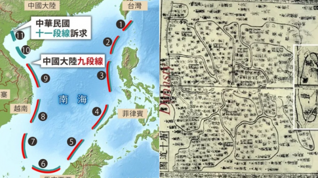
International News — In the realm of historical cartography and geopolitical narratives, few artifacts have stirred as much controversy as the so-called Qinghua Map. Purportedly dating back to the early 18th century during the Qing Dynasty, this map has been at the center of heated debates due to its depiction of the infamous “9-dash line,” a demarcation that has become emblematic of China’s territorial claims in the South China Sea. However, upon closer examination by a consortium of historians, cartographers, and forensic experts, the Qinghua Map has been exposed as a sophisticated fabrication, casting a shadow over the legitimacy of historical claims in contemporary maritime disputes.
The Discovery of the Qinghua Map
The Qinghua Map first surfaced in 2010, when it was allegedly discovered in the archives of the Qinghua University Library. The map immediately drew attention due to its detailed representation of China’s maritime boundaries, including the contentious 9-dash line, which encompasses an area significantly beyond China’s internationally recognized territorial waters. Its emergence was timely, coinciding with a period of escalating tensions in the South China Sea involving China and several Southeast Asian nations.
Initial Celebrations and Scrutiny
The discovery of the Qinghua Map was initially celebrated in some quarters as a historical vindication of China’s longstanding territorial claims. It was presented as incontrovertible evidence that the boundaries now contested had been recognized by China’s ancestors centuries before. However, the map also attracted skepticism from the outset. Questions were raised about its provenance, the anachronistic nature of the 9-dash line, and the absence of similar depictions in other historical documents from the same period.
The Investigation and Its Findings
Prompted by the growing controversy, an international team was assembled to conduct a comprehensive analysis of the Qinghua Map. Their investigation encompassed a wide array of techniques, from radiocarbon dating of the paper and ink analysis to a meticulous examination of the cartographic style and linguistic assessment of the annotations. The findings were revealing:
- Radiocarbon Dating: The paper on which the map was drawn was dated to the late 20th century, several centuries later than claimed.
- Ink Analysis: The composition of the ink did not match that used in genuine Qing Dynasty documents, suggesting modern production.
- Cartographic Inconsistencies: The style and conventions used in the map were found to be inconsistent with those of early 18th-century Chinese cartography.
- Linguistic Anachronisms: The annotations on the map contained modern vernacular and terminology not in use during the Qing Dynasty.
Implications and Reactions
The revelation that the Qinghua Map was a fabrication has had profound implications. It has underscored the dangers of using historically dubious artifacts to justify contemporary territorial claims, highlighting the need for rigorous scrutiny of historical documents that emerge in politically sensitive contexts.
The exposure of the map’s inauthenticity has also prompted a broader discussion about the role of historical evidence in territorial disputes and the importance of international law and dialogue in resolving such conflicts. While the Qinghua Map may have been discredited, the underlying tensions in the South China Sea persist, reminding us that the path to resolution lies not in the past, but through cooperative engagement in the present.
In the aftermath, the scholarly community has called for increased vigilance against the fabrication and misuse of historical documents. The Qinghua Map saga serves as a cautionary tale about the intersection of history, nationalism, and the complex quest for identity and sovereignty in a globalized world.
[READ] The Philippines owns the West Philippine Sea & not China


